From BART to the Bay by bike
 |
By Steve Price and Janet Byron
On April 16, El Cerrito Strollers & Rollers will lead an outing from El Cerrito Plaza BART to the Bay Trail. We'll travel via El Cerrito and Richmond Annex streets and the Sacramento Street pedestrian bridge over I-80. On the Bay Trail, we'll continue to Armistice Brewery in Richmond. (It's about 8-9 miles roundtrip). We’ll explore the possibilities for improving this little-known route to the Bay Trail to make it safer and more accessible for walkers and cyclists.
El Cerritans have dreamed of a safe bicycling route to the Bay Trail for decades. A bike lane down Central Avenue would be challenging given the narrow and busy right-of-way of the street. An alternative route along Cerrito Creek would be scenic if a safer crossing of San Pablo Avenue could be worked out, but that wouldn't be very accessible for our neighbors in the Richmond Annex. And then both routes would have to deal with the complicated intersection at I-80 and Central Avenue, where streets and on- off-ramps are numerous. The El Cerrito–Richmond Annex Community Bike and Pedestrian Safety workshop, which El Cerrito Strollers & Rollers hosted last year with SafeTREC and CalWalks, reminded us that intersections with freeway on- and off-ramps are where many bike, pedestrian, and car accidents occur.
 |
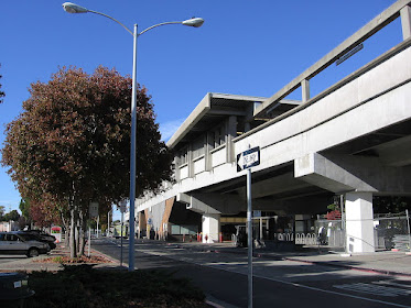
| Sacramento Street bridge, eastern approach |
If Berkeley can have bike/pedestrian bridges over I-80, why can't we? But a bridge for El Cerritans would have to contend with two freeways close together, I-80 and I-580. It's not to say it can't be done, but the engineering and costs would be challenging.
A more cost-effective, short-term path to the Bay Trail could be the route via the Sacramento Street bridge, shown on the map above. This little-known route needs improvement, but for relatively modest cost compared with building new infrastructure like a bridge. At minimum, wayfinding signs and bike striping would go a long way toward letting residents in El Cerrito and Richmond know that this route even exists.
 |
| Sacramento Street bridge, western approach |
Bicycling from El Cerrito Plaza BART north along the Ohlone Greenway, a bike rider gets within yards of Eureka Avenue on the west side of the BART tracks. There is a steep asphalt ramp that connects to a narrow sidewalk leading to Eureka. Conflicts with pedestrians walking to Centennial Park are not unusual, so a better connection needs to be engineered. Riding west on Eureka brings you to a new HAWK pedestrian signal that will make crossing San Pablo Avenue into the Richmond Annex safer.
Eureka here almost perfectly aligns with Columbia Avenue in Richmond Annex, making this one of the few street routes that goes east/west across San Pablo Avenue. Most streets on both sides of the San Pablo Avenue end with T intersections at San Pablo Avenue but don't go through to the other side. (The reverse trip from the Richmond Annex would make it possible for Annex bicycle riders to safely access the Ohlone Greenway and BART.)
From there you bicycle on quiet residential streets in Richmond Annex to get to a little-known pedestrian bridge over I-80 at the west end of Sacramento Street. The bridge needs some engineering work to give it larger landings on both ends, allowing walkers and cyclists space away from cars.
From the bridge it is a downhill ride on wide San Joaquin Street to Central Avenue with no bike lanes. San Joaquin Street is not very busy with traffic but could use bike lanes and traffic calming improvements to make bicycling more comfortable. A right westward turn on Central Avenue puts you on an unprotected bike lane across the Central Avenue bridge over I-580. On the other side is the Bay Trail! The route from BART to the Bay Trail is 1.44 miles.
The roadway to return from the Bay Trail back to El Cerrito over the Central Avenue bridge is another story. After crossing the bridge on an unpainted, poorly striped bike lane, cyclists must either wait at the large, confusing I-580 intersection to cross north over 5 lanes of traffic in a crosswalk to reach San Joaquin Street, or navigate across two lanes of traffic to use the left-turn lane.
El Cerrito Strollers & Rollers is again partnering with SafeTREC and CalWalks to host a community workshop on developing this route into an easier-to-follow, safer route for walkers and bikers.
We hope you’ll join us on the ride to Armistice Brewery on April 16 (meet at 3:30 p.m. at El Cerrito Plaza BART) and at the workshop (watch our newsletter for more details).
 |
| Bird's eye view of the Sacramento Street bridge over I-80, looking east (Google Earth) |

Comments
Post a Comment